|
May 21 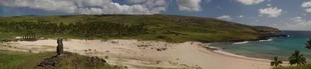
Panorama of Anakena beach, Easter Island.
Easter Island (Rapa Nui in the Rapa Nui language, Isla de Pascua in Spanish language), is a Polynesian island in the southeastern Pacific Ocean, at the southeasternmost point of the Polynesian triangle. The island is an overseas territory of Chile. Easter Island is famous for its monumental statues, called moai, created by the Rapanui people. It is a world heritage site with much of the island protected within the Rapa Nui National Park.
To read more, and for additional links, please visit >> link <<
(Image courtesy Wikipedia, GNU licensed >> link <<) May 21 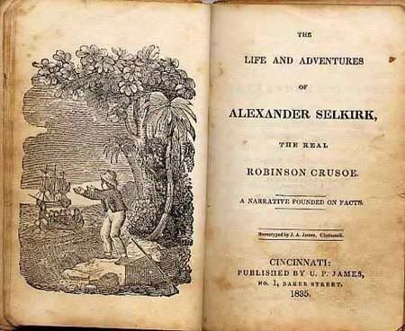
Alexander Selkirk, born Alexander Selcraig (1676 – 13 December 1721), was a Scottish sailor who spent four years as a castaway on an uninhabited island.
It is probable that his travails provided the inspiration for Daniel Defoe's novel Robinson Crusoe.
In October 1704, after the ships had parted ways because of a fight between Stradling and Dampier, the Cinque Ports was brought by Stradling to the uninhabited archipelago of Juan Fernández for a mid-expedition restocking of supplies and fresh water. Selkirk had grave concerns by this time about the seaworthiness of this vessel (the Cinque Ports, indeed, later foundered, losing most of its hands). He tried to convince some of his crewmates to desert with him, remaining on the island; he was counting on an impending visit by another ship. No one else agreed to come along with him. Stradling, who was tired of Selkirk's troublemaking, declared that he would grant him his wish and leave him alone on Juan Fernández. Selkirk promptly regretted his decision. He chased and called after the boat, to no avail. Selkirk lived the next four years and four months without any human company. All he had brought with him was a musket, gunpowder, carpenter's tools, a knife, a Bible and some clothing.
To read more about his adventure, and for additional links, please see >> link << (Wikipedia) May 21 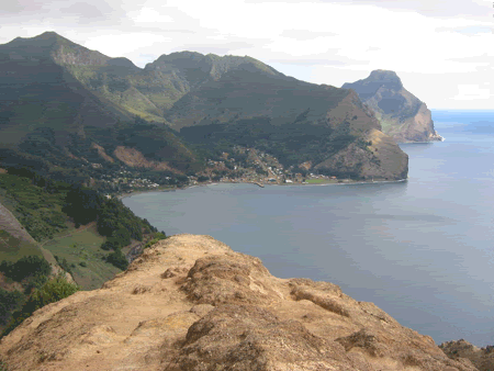
Town San Juan Bautista, Robinson Crusoe, Cumberland Bay
It was here that the sailor Alexander Selkirk was marooned in 1704 and lived in absolute solitude for four years and four months. The sailor inspired Daniel Defoe to write the classic novel, Robinson Crusoe. To reflect the literary lore associated with the island, the Chilean government named the location Robinson Crusoe Island in 1966.
The island has a mountainous and undulating terrain, formed by ancient lava flows which have built up due to numerous volcanic episodes. The climate is distinctly Mediterranean, with clearly defined warm, dry summers and cooler, wet winters.
To read more about the Island, please see the following Wikipedia page: Robinson Crusoe Island >> link <<
(Image courtesy Wikipedia, GNU licensed >> link <<) May 21 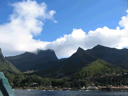
The town of San Juan Bautista in Cumberland Bay,
Robinson Crusoe Island
The Juan Fernández Islands is a sparsely inhabited island group reliant on tourism and fishing in the South Pacific Ocean, and is composed of several volcanic islands. The islands are mainly known for having been the home to the sailor Alexander Selkirk for four years, which inspired the novel Robinson Crusoe.
(Image courtesy Wikipedia, GNU licensed >> link <<) May 16 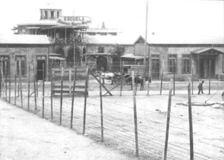
The Santa María de Iquique Massacre was a Chilean massacre which occurred on December 21, 1907. In the massacre, an undetermined number of saltpeter workers were killed in a strike while housed in the Santa María School at the port of Iquique. The events that give rise to the facts occur during the peak of the production of saltpeter in the Chilean Norte Grande, below the parliamentary governments. The strike, provoked by the terrible working conditions and exploitations of the workers, was repressed by means of an indiscriminate use of the army's force by part of the government of former-president Pedro Montt. General Roberto Silva Renard, commanding the military units under instructions of the minister of the interior Rafael Sotomayor Gaete, ordered to repress the protests, killing one hundred workers and treating the survivors especially hard.
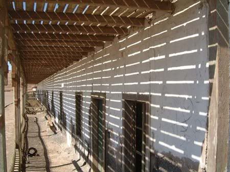
Humberstone Chile
(Image Courtesy Wikipedia, GNU Licensed >> link <<)
Description from UNESCO World Heritage Site web site
"Humberstone and Santa Laura works contain over 200 former saltpeter works where workers from Chile, Peru and Bolivia lived in company towns and forged a distinctive communal pampinos culture. That culture is manifest in their rich language, creativity, and solidarity, and, above all, in their pioneering struggle for social justice, which had a profound impact on social history. Situated in the remote desert Pampa, one of the driest deserts on earth, thousands of pampinos lived and worked in this hostile environment, for over 60 years, from 1880, to process the largest deposit of saltpeter in the world, producing the fertilizer sodium nitrate that was to transform agricultural lands in North and South America, and in Europe, and produce great wealth for Chile. Because of the vulnerability of the structures and because of the impact of a recent earthquake, the site was also placed on the List of World Heritage in Danger, to help mobilize resources for its conservation."
To read more and source of above:
-
Humberstone and Santa Laura Saltpeter Works >> link <<
-
Santa María de Iquique School Massacre >> link << May 16 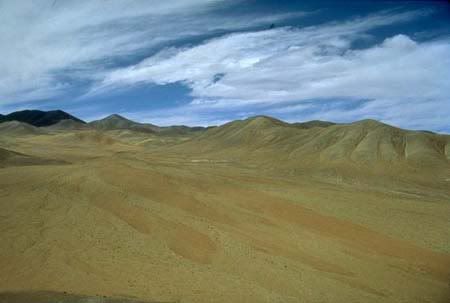
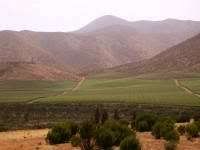
Making our way south through Chili, we are face to face with the Atacama Desert on our way to Iquique.
Atacama is one of the driest places on Earth, and is virtually sterile because it is blocked from moisture on both sides by the Andes mountains and by the Chilean Coast Range. The cold Humboldt Current and the anticyclone of the Pacific are essential to keep the dry climate of Atacama Desert. The average rainfall in the Chilean region of Antofagasta is just 1 mm per year. Some weather stations in the Atacama have never received rain. Evidence suggests that the Atacama may not have had any significant rainfall from 1570 to 1971. It is so arid that mountains that reach as high as 22,590 feet are completely free of glaciers and, in the southern part may have been glacier-free throughout the Quaternary - though permafrost extends down to an altitude of 4,400 metres and is continuous above 5,600 metres. Studies by a group of British scientists have suggested that some river beds have been dry for 120,000 years.
Iquique has one of the largest duty-free commercial port centers (or Zona Franca) of South America and has been traditionally called Zofri. There are around 2.4 km² of warehouses, banking branches, and restaurants.
Although the city was founded in the sixteenth century, there is evidence of habitation in the area by the Chango people as early as 7000 BC. During colonial times, Iquique was part of the Viceroyalty of Peru as much of South America was at the time, and remained part of Peruvian territory until the end of the 19th century. Iquique's early development was due in large part to the discovery of mineral riches, particularly the presence of large deposits of sodium nitrate (Chilean saltpeter, locally called salitre) in the Atacama Desert (then part of Peruvian territory). See above post for info on the saltpeter towns.
Changos was a tribe of native South Americans who appear to have originally inhabited the Peruvian coast and spread south to the coast of Atacama, in northern Chile and further south. They lived from fishing, gathering shellfish, and hunting sea lions. In former times they used rafts of inflated sealskins, lived in sealskin huts, and slept on heaps of dried seaweed.
For more information on the above and source:
May 16 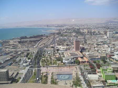
Arica is a port city in northern Chile, located only 11 miles south of the border with Peru, and the first city we came into from Bolivia. Arica serves landlocked Bolivia via railroad.
Arica is a port city in northern Chile, located only 11 miles south of the border with Peru. Archaeological research has indicated the site of Arica was inhabited by different native groups for at least ten thousand years.
The Potosi silver mine was the largest such mine in world history. Because of it, Arica became a crucial port for the Spanish Empire. This port was visited (and looted) by such famous pirates and bucaneers as Francis Drake, Thomas Cavendish, Richard Hawkins, Joris van Spilbergen, Watling, Simón de Cordes, Leandro de Valencia, Sharp, Dampier, and Clipperton.
Near the city is the Azapa Valley, an oasis where vegetables and Azapa olives are grown. Economically, it is an important port for Chilean ore, and its tropical latitude, dry climate, and the city's beach, have made Arica a popular tourist destination. May 16 
Chile's unusual, ribbon-like shape - 4,300 km long and on average 175 km wide - has given it a hugely varied climate, ranging from the world's driest desert - the Atacama - in the north, through a Mediterranean climate in the center, to a snow-prone Alpine climate in the south, with glaciers, fjords and lakes. The northern Chilean desert contains great mineral wealth, principally copper. The relatively small central area dominates the country in terms of population and agricultural resources. This area also is the cultural and political center from which Chile expanded in the late 19th century, when it incorporated its northern and southern regions. Southern Chile is rich in forests and grazing lands and features a string of volcanoes and lakes. The southern coast is a labyrinth of fjords, inlets, canals, twisting peninsulas, and islands. The Andes Mountains are located on the eastern border.
There is no single picture that can sum up the majority of environment in Chili. Comparing it to California probably comes closes, but include Oregon and Washington states into the picture as well.
To see a series of pictures that portray Chile well, and read up on the country, the following is a good cross-section: Chile, Wikipedia >> link <<
I explored information on Chile during our drive over and into the northern section. The history of Chile IMO is loaded with many battles, and sadly atrocities towards the indigenous and poverty economic class. The politic's of Chile have definitely seen extremes, from communism to socialism. The influence of Fidel Castro and the US (Nixon era) is definitely worth noting. The current President, the first female President in SA, has her hands full.
For such a small, sliver of a country, Chile holds a very large piece of the economic pie in South America. Yet, at a huge price on the economic poor in the country. Middle class for a very long while has not existed in Chile. The new President is currently attempting to bring back the middle class. This particular element is notable in the International country standings.
Onward we go exploring Chile, hoping the current volcanic activity can be somewhat avoided. I feel for the people having to contend with it, but I can't afford to place myself into the fumes and tragedy. May 15 There are several popular models of migration to the New World proposed by the anthropological community. The question of how, when and why humans first entered the Americas is of serious interest to anthropologists and has been a subject of heated debate for centuries. As new discoveries come to light, past hypotheses are reevaluated and new theories constructed. To read a full page on this topic, a good and quick run down can be found on this Wikipedia site page >> link <<
I wanted to make this posted entry because I keep loosing the page during research, and also keep running into the debate in just about every article and web site having to do with any country in Central and South America. The word 'repeat' is an understatement :-)
I am siding with others that the older migration theory has holes in it. By no means am I educated to be able to actually make a statement yea or nay in either direction. Simply as an outsider, reading along, being on a fictional world travel, something just does not add up to a 100% total top down migration from the Bering Land Bridge, which spanned what is now the Bering Strait.
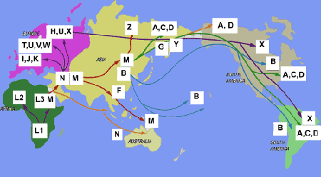
A model of human migration based on Mitochondrial DNA
Looking at the DNA charting, I'm still not convinced of a total top down Bering Strait migration. Who say's they've found all evidence from ancient times - yet, to be making such determinations? And 'B' could only have come from the northern point of the Bering Strait, not from where the Hawaiian Islands are, or that 'M' in Australia isn't in SA somewhere? Any why do the L DNA only exist in Africa?
I just do not think we know enough yet to be making any absolute summations, and should be more open to new discoveries and advancements in DNA technology. DNA is all great and wonderful, but it is not perfected yet.
To read more on the above, see: Human mitochondrial DNA haplogroup >> link <<
Anyways, the post is made so I can find it again :-) |